Cantref Gwaelod
Have you ever wondered 'What lies beneath the sea'?
If you go for a walk along the beach at Borth in Cardigan Bay you can sometimes see tree stumps when the waves draw back at low tide. The photograph shows one of the stumps preserved in peat. This was once a tall Pine tree during a time known as the Ice Age, about 8,000 years ago. You can find drowned forests in other parts of Wales, such as Marros beach in Carmarthen Bay and Lleniog beach near Beaumaris.

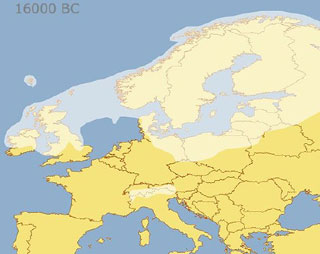
During the Ice Age, about a third of the Earth was frozen and covered in sheets of ice, sometimes hundreds of metres thick. There was no Irish Sea and you could have walked across to Ireland from Wales. The ice made Wales the shape it is today. But over a very long time the temperature started to rise. The ice melted and the powerful waters moved rocks, deepened valleys and covered the land, including the trees.

If you travel on a boat around the Welsh coast or walk along a coastal path, you should see cliffs that are strange shapes caused by the sea, wind and rain. In some parts, such as Cardigan Bay, you might also see very long causeways jutting out to sea. These are made up of clay, gravel, pebbles and boulders (usually called till) which have been shifted thousands of years ago by the Ice Age.
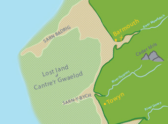
One of these is St Patrick's Causeway (Sarn Badrig). This is about 17 metres in length and runs out to the sea from Mochras near Harlech.

About 1500 years ago, there was a kingdom called Cantre's Gwaelod in what is now Cardigan Bay. It had sixteen villages with very good farmland. The villagers used the seaweed as a fertiliser. The king was Gwyddno Garanhir. He was also called 'Gwyddno Longshanks' because he was so tall. His great fort or palace was seven miles out to sea, west of Aberystwyth. He protected his kingdom from the sea by building a huge dyke or wall with floodgates. These were opened at low tide to drain the water from the land and closed when the tide returned. The king's friend, called Seithennin, was in charge of watching over the gates.

One very stormy night the waves crashed against the dyke. Some say that Seithennin fell asleep because he had drunk too much wine, after attending the king's party. Others say that he was distracted by a woman whom he loved and he was jealous because she was about to marry someone else. Whatever the reason, he forgot to close the gates tight. The sea rushed in and flooded the land, destroying the villages. The king and his people fled for their lives.

It is said that on a calm evening you can hear the church bells of Cantre's Gwaeolod. Click on here to read a poem about this written in Victorian times.
We do not know how much truth is in the legend of Cantre'r Gwaelod. Did Seithennin really drink too much wine and fall asleep? Are the sarnau really the remains of the king's sea defences? Did the king have a sea palace? Many people believe there is some truth in the legend.
Phil Hughes, chairman of the Friends of Cardigan Bay, said:
"There is a lot of evidence to suggest that Cantre'r Gwaelod existed and I believe there was land out there."
Here is a map from 1920. It is from a book describing changes to the coastline. The author says that the sea was much further west than it is now. But over the centuries the sea has moved east and eroded the cliffs and changed the course of rivers, such as the river Mawddach. This once flowed through the village of Llanaber. We know this because archaeologists have found objects such as a ship's anchor underground. Click map to enlarge

Another writer called Samuel Lewis described a collection of loose stone out at sea as 'the palace of Gwyddno' .

Scientists tell us that about 7,000 years ago there was a forest beneath the sea at Cardigan Bay. They can now use technology to create maps of sea beds to show traces of where people once lived. This new technology might one day answer our questions. But the legend of Cantre'r Gwaeolod lives on.

Key Questions
Question 2
Question 3
Cantre'r Gwaelod
Use the page corners to read the book

